
The primary responsibility of Sierra Streams in the Sierra Water Trust project is the monitoring of stream flow in Deer Creek and its major tributaries. It is important for the purposes of the project to monitor stream flow at multiple locations. In this way we can calculate the relative contributions of each tributary to flow in the mainstem of the creek and the amount of water diverted from the creek by the Nevada Irrigation District.
Seven gauging stations targeting major tributaries in the watershed and several locations on the mainstem of Deer Creek that are in close proximity to NID diversion points were installed in November 2010. Two additional gauging stations will be installed after the winter season in early 2011. These nine stations are listed below and shown on the Gauging Stations Overview Map.
)
Stream flow gauging stations. Click map for full-size image with legend.
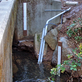
Stream-flow gauging station on Little Deer Creek near Pioneer Park.. The station includes an automatic water-level sensor and pressure transducer (in PVC piping on the right), two staff plates for comparison with the automatic sensor readings (plates are mounted to a boulder in-stream for low flows and on the bridge abutment for higher flows), and a conductivity sensor (in PVC piping to the left of the water level sensors). The box housing the gauging station electronics is out of the frame above the PVC piping. Photo by Justin Wood, 2011.
Mainstem Gauging Stations
Nevada Street Bridge
GPS Coordinates: 39.262245, -121.016193
Location: 18.5 miles upstream from the Yuba River
Watershed drainage area: 26.3 mi2
Elevation: 2448 ft
Hydrologic Unit: 180201250802
Period of Record: November 2010 to present
The streamflow gauging station on Deer Creek at Nevada Street bridge is located in downtown Nevada City. The stream flow gauging instrumentation is located on the river right side of the middle bridge abutment, towards the downstream end of the bridge. Instrumentation at this site includes a Solinst Levelogger Gold Datalogger for continuous water level and water temperature measurements, and two staff gauges.
This location on Deer Creek is important to gauge because it provides important data on flows in Nevada City, upstream of the majority of the major mines that are located adjacent to Deer Creek. Additionally, preliminary rating curves were developed during the 2006 water year at this location, for calculating mercury and sediment loads moving through Nevada City. Upgrading the stream flow gauging infrastructure at this site has been a priority since that initial field season. Two FoDC monitoring sites are located on mainstem Deer Creek in the vicinity of the stream flow gauging station: Site 2 upstream of the station and Site 3 downstream of the station. Gauging this portion of Deer Creek will provide an important hydrologic dataset for comparison with other information collected on the creek, including data on water quality, benthic macroinvertebrates, algae, fish, physical habitat, heavy metals, and precipitation. In addition, streamflow gauging at this site will provide a long-term dataset for assessing the impacts of water management by Nevada Irrigation District, the impacts associated with climate change, and the success of restoration projects, and for developing a mercury TMDL for the Deer Creek watershed.
Bitney Springs Road
GPS Coordinates: 39.246589, -121.112026
Location: 11.85 miles upstream from the Yuba River
Watershed drainage area: 43.2 mi2
Elevation: 1986 ft
Hydrologic Unit: 180201250803
Period of Record: November 2010 to present
The streamflow gauging station on Deer Creek at the Bitney Springs Road bridge is located downstream of Nevada City, at the historic Bitney Springs bridge over Deer Creek. The stream flow gauging instrumentation is located on the river right side of a bridge abutment, on the downstream end of the historic bridge. Instrumentation at this site includes a Solinst Levelogger Gold Datalogger for continuous water level and water temperature measurements, and two staff gauges.
This location on Deer Creek is important to gauge because it provides data on flows downstream of numerous major tributaries and downstream of Nevada City, with its large concentration of gold mining sites. Preliminary rating curves were developed at this site during the 2006 water year, for calculating mercury and sediment loads moving through Nevada City. Upgrading the streamflow gauging infrastructure at this site has been a priority since the 2006 field campaign. One FoDC monitoring site is located on mainstem Deer Creek in the vicinity of the streamflow gauging station, Site 5 approximately 0.5 miles upstream of the station. Gauging this portion of Deer Creek will provide an important hydrologic dataset for comparison with other information collected on the creek, including data on water quality, benthic macroinvertebrates, algae, fish, physical habitat, heavy metals, and precipitation. In addition streamflow gauging at this site will provide a long-term dataset for assessing the impacts of water management by Nevada Irrigation District, the impacts associated with climate change, and the success of restoration projects, and for developing a mercury TMDL for the Deer Creek watershed.
Lake Wildwood reservoir inlet
GPS Coordinates: 39.238997, -121.187363
Location: 6.28 miles upstream from the Yuba River
Watershed drainage area: 49.8 mi2
Elevation: 1209 ft
Hydrologic Unit: 180201250804
Period of Record: To be installed Summer 2011
The streamflow gauging station on Deer Creek at the Lake Wildwood Reservoir inlet will be installed in the summer of 2011 in the community of Lake Wildwood, at the Lake Wildwood Drive bridge over Deer Creek. The streamflow gauging instruments will be located on the left bank of the creek, mounted onto the bridge abutment or concrete weir located at the reservoir inlet. Instrumentation at this site will include a Solinst Levelogger Gold Datalogger for continuous water level and water temperature measurements, and two staff gauges.
This location on Deer Creek is important to gauge because it will provide data on streamflows entering the reservoir, which can be compared to other mainstem Deer Creek sites upstream and downstream of the reservoir to characterize flows in the watershed. Gauging this location is critical because Lake Wildwood Reservoir captures the majority of material (sediment, organic matter, aquatic organisms, heavy metals, etc.) that enters the reservoir. Gauging stations at the inlet, spillway, and downstream of the reservoir will allow for quantification of flows and loads of various contaminants moving through the Deer Creek watershed. Comparing the data from the Lake Wildwood Reservoir spillway and weir locations against the Lake Wildwood Reservoir inlet will allow for a basic mass balance of many variables to be determined (fine sediment and mercury are two examples). One FoDC monitoring site is located in the vicinity of the Inlet gauging station: Site 6, located 0.25 miles upstream. Streamflow gauging at this site will provide a long-term dataset for evaluating stream flows into Lake Wildwood Reservoir and lower Deer Creek, assessing potential impacts associated with climate change, evaluating the success of restoration projects, quantifying natural flows into the reservoir, and developing a mercury TMDL for the Deer Creek watershed.
Lake Wildwood Reservoir spillway
GPS Coordinates: 39.236295, -121.217189
Location: 4.25 miles upstream from the Yuba River
Watershed drainage area: 54.5 mi2
Elevation: 1208 ft
Hydrologic Unit: 180201250804
Period of Record: November 2010 to current year
The streamflow gauging station on Deer Creek at the Lake Wildwood Reservoir spillway outlet is located in the community of Lake Wildwood, at the Lake Wildwood Reservoir spillway on Deer Creek. The streamflow gauging instrumentation is located on the river left side of the spillway, mounted to the concrete spillway abutment. Instrumentation at this site includes a Solinst Levelogger Gold Datalogger for continuous water level and water temperature measurements, and two staff gauges.
This location on Deer Creek is important to gauge because it provides data on streamflows leaving the reservoir, which can be compared to other mainstem Deer Creek sites upstream and downstream of the reservoir to characterize flows in the watershed. A rating curve exists for the reservoir spillway, which will be used to relate water level above the spillway crest to a streamflow volume. The spillway location, however, does not accurately capture low streamflows leaving the reservoir. Gauging this location is critical because Lake Wildwood Reservoir captures the majority of material (sediment, organic matter, aquatic organisms, heavy metals, etc.) that enters the reservoir, and having gauging stations at the inlet, spillway outlet, and downstream of the reservoir will allow for quantification of flows and loads of various contaminants moving through the Deer Creek watershed. Comparing the data from the Lake Wildwood Reservoir spillway and weir locations against the Lake Wildwood Reservoir inlet will allow for a basic mass balance of many variables to be calculated (fine sediment and mercury are two examples). Streamflow gauging at this site will provide a long-term dataset for evaluating stream flows into Lake Wildwood Reservoir and lower Deer Creek, assessing potential impacts associated with climate change, evaluating the success of restoration projects, quantifying natural flows into the reservoir, and developing a mercury TMDL for the Deer Creek watershed.
Lake Wildwood Reservoir weir
GPS Coordinates: 39.235585, -121.220527
Location: 4.0 miles upstream from the Yuba River
Watershed drainage area: 55.5 mi2
Elevation: 1135 ft
Hydrologic Unit: 180201250804
Period of Record: September 2011 to current year
The streamflow gauging station on Deer Creek at the Lake Wildwood Reservoir Weir was installed in the summer of 2011 in Penn Valley, downstream of the Lake Wildwood Reservoir spillway at the concrete abutment where a weir is located during irrigation season. Instrumentation at this site includes a Solinst Levelogger Gold Datalogger for continuous water level measurements and one staff gauge.
This location on Deer Creek is important to gauge because it augments the Lake Wildwood Reservoir spillway gauging station by providing data on low streamflows during summer and fall months, including irrigation season. Gauging this location is critical because the Lake Wildwood Reservoir spillway gauging station does not provide high-resolution low-flow data, and is better suited for higher streamflows due to the existing spillway rating curve. Gauging at the weir immediately downstream of the reservoir is necessary for quantifying low streamflows, which are predominant during a large portion of the year (including irrigation season, summer, and early fall). In addition, this location is important because Lake Wildwood Reservoir captures the majority of material (sediment, organic matter, aquatic organisms, heavy metals, etc.) that enters at the Reservoir inlet. Comparing the data from the Lake Wildwood Reservoir spillway and weir locations against the Lake Wildwood Reservoir inlet allows for a basic mass balance of many variables to be calculated (fine sediment and mercury are two examples). Additionally, monitoring the quantity of stream flow in Deer Creek downstream of Lake Wildwood Reservoir is important because there exist water rights requirements and Chinook salmon and steelhead trout downstream of the reservoir. Two FoDC monitoring sites are located in the vicinity of the weir gauging station; one at the weir for storm sampling and reservoir drawdown releases, and Site 7 located approximately one mile downstream of the weir gauging station, near the Lake Wildwood Reservoir Wastewater Treatment Plant. Streamflow gauging at this site will provide a long-term dataset for evaluating stream flows into lower Deer Creek, assessing potential impacts associated with climate change, evaluating the success of restoration projects, and developing a mercury TMDL for the Deer Creek watershed.
Tributary Gauging Stations
North Fork of Deer Creek
GPS Coordinates: 39.295809, -120.886555
Location: 0.12 miles upstream from Deer Creek mainstem
Watershed drainage: 5.51 mi2
Elevation: 3151 ft
Hydrologic Unit: 180201250801
Period of Record: To be installed in Summer 2011
The streamflow gauging station on the North Fork of Deer Creek will be installed in the summer of 2011 at a location upstream of Nevada City and Scotts Flat Reservoir, upstream of the confluence of the North Fork and South Fork of Deer Creek in the Tahoe National Forest. Instrumentation at this site will include a Solinst Levelogger Gold Datalogger for continuous water level measurements and two staff gauges.
The North Fork of Deer Creek is important to gauge because it is a major tributary in the upper watershed that contributes significant volumes of flow and material (sediment, organic matter, aquatic organisms, etc.) to mainstem Deer Creek upstream of Scotts Flat Reservoir. In addition there are no major diversions on the North Fork of Deer Creek, which will allow this gauging station to serve as a proxy for characterizing natural stream flows in the upper watershed and for comparing managed stream flows on the South Fork of Deer Creek. One FoDC monitoring site is located in the vicinity of the gauging station, downstream of the confluence of the North Fork and South Fork of Deer Creek. Gauging the North Fork of Deer Creek will provide an important hydrologic dataset for comparison with other information collected on the creek, including data on water quality, benthic macroinvertebrates, algae, fish, physical habitat, and precipitation. In addition, streamflow gauging at this site will provide a long-term dataset for assessing the impacts of water management by Nevada Irrigation District, the impacts associated with climate change, and the success of restoration projects.
Little Deer Creek
GPS Coordinates: 39.260816, -121.012603
Location: 0.23 miles upstream from Deer Creek
Watershed drainage area: 3.71 mi2
Elevation: 2478 ft
Hydrologic Unit: 180201250802
Period of Record: October 2010 to present
The streamflow gauging station on Little Deer Creek is located in Nevada City upstream of the Nimrod Street bridge crossing, on private property near Pioneer Park. The stream flow gauging instruments are located on the right bank of the creek. Instrumentation at this site includes a pressure transducer and bubbler for continuous water level measurements, two staff gauges, a tipping-bucket rain gauge, and a conductivity sensor. There is also a weather station on site that collects data on ambient air temperature, barometric pressure, and relative humidity.
Little Deer Creek is important to gauge because it is a major tributary that contributes significant volumes of flow and material (sediment, organic matter, aquatic organisms, heavy metals, etc.) to mainstem Deer Creek. Three FoDC monitoring sites are located on Little Deer Creek in the vicinity of the stream flow gauging station. Gauging Little Deer Creek will provide an important hydrologic dataset for comparison with other information collected on the creek, including data on water quality, benthic macroinvertebrates, algae, fish, physical habitat, and precipitation. In addition, streamflow gauging at this site will provide a long-term dataset for assessing the impacts of water management by Nevada City and Nevada Irrigation District, the impacts associated with climate change, and the success of restoration projects, and for developing a mercury TMDL for the Deer Creek watershed.
Gold Run Creek
GPS Coordinates: 39.260034, -121.019026
Location: 0.07 miles upstream from Deer Creek
Watershed drainage area: 1.99 mi2
Elevation: 2457 ft
Hydrologic Unit: 180201250802
Period of Record: November 2010 to present
The streamflow gauging station on Gold Run Creek is located in Nevada City, off South Pine Street, on private property behind Flume's End. The stream flow gauging instrumentation is located on the left bank of the creek. Instrumentation at this site includes a Solinst Levelogger Gold Datalogger for continuous water level and water temperature measurements, and one staff gauge.
Gold Run Creek is important to gauge because it is a major tributary that contributes significant volumes of flow and material (sediment, organic matter, aquatic organisms, heavy metals, etc.) to mainstem Deer Creek. Additionally, sampling efforts have indicated that Gold Run Creek is a significant contributor of mercury and fine sediment to the mainstem of Deer Creek. One FoDC monitoring sites is located on Gold Run Creek a quarter mile downstream of the streamflow gauging station. Gauging Gold Run Creek will provide an important hydrologic dataset for comparison with other information collected on the creek, including data on water quality, benthic macroinvertebrates, algae, fish, physical habitat, heavy metals, and precipitation. In addition, streamflow gauging at this site will provide a long-term dataset for assessing potential impacts associated with climate change, evaluating the success of restoration projects, and developing a mercury TMDL for the Deer Creek watershed.
Squirrel Creek
GPS Coordinates: 39.210543, -121.202177
Location: 2.8 miles upstream from Deer Creek
Watershed drainage area: 24.8 mi2
Elevation: 1349 ft
Hydrologic Unit: 180201250803
Period of Record: November 2010 to present
The streamflow gauging station on Squirrel Creek is located in Penn Valley, at the Pleasant Valley Road bridge over Squirrel Creek. The stream flow gauging instrumentation is located on the river left side of the middle bridge abutment. Instrumentation at this site includes a Solinst Levelogger Gold Datalogger for continuous water level and water temperature measurements, and two staff gauges.
Squirrel Creek is important to gauge because it is a major tributary that contributes significant volumes of flow and material (sediment, organic matter, aquatic organisms, heavy metals, etc.) to mainstem Deer Creek downstream of Lake Wildwood Reservoir. Sampling efforts have indicated that Squirrel Creek is a major source of mercury and fine sediment to the mainstem of Deer Creek downstream of Lake Wildwood Reservoir. Additionally, monitoring the quantity of streamflow in Squirrel Creek is important because the tributary contributes flow to lower Deer Creek, which supports anadromous fish during portions of the year. Two FoDC monitoring sites are located on Squirrel Creek; Site 15 is located approximately three miles upstream of the gauging station and Site 16 is located approximately two miles downstream. Gauging Squirrel Creek will provide an important hydrologic dataset for comparison with other information collected on the creek, including data on water quality, benthic macroinvertebrates, algae, fish, physical habitat, heavy metals, and precipitation. In addition streamflow gauging at this site will provide a long-term dataset for evaluating stream flows into lower Deer Creek, assessing impacts associated with climate change, evaluating the success of restoration projects, and developing a mercury TMDL for the Deer Creek watershed.


)
)
)
)
)
)
)
)
)